Platform on civil engineering, underground infrastructure, energy, construction equipment & construction machinery

A range of innovative techniques are being used for the Gorinchem-Waardenburg dike reinforcement project. One of these is the Locator One. A Dutch development for measuring subsidence and deformations. The innovative character lies mainly in the combination of autonomous and accurate measurement with a high predictability of the data.
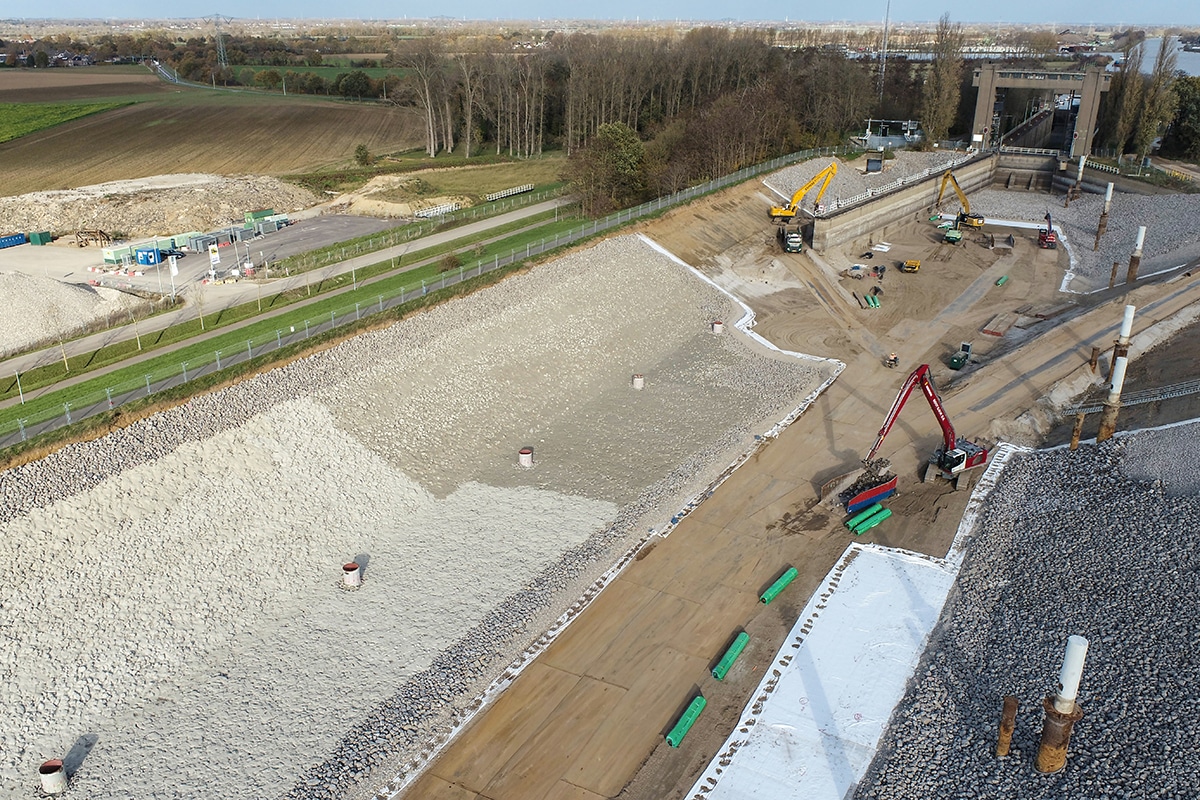
As described in detail in this special, over the next five years the dike between Gorinchem and Waardenburg will be raised, widened and strengthened over a total length of 23 kilometers. To maintain control over the embankments during construction, the dike body is normally measured by a surveyor. Due to the greasy clay soil, this is heavy work and not entirely without danger, such as collision and tripping hazards. With the objective of increasing safety on the construction site along with a desire for innovation, Locator One proved to be the ideal application for the project. "What benefits applying the Locater One would bring we didn't know exactly a year ago at the start of the project, but we were looking for innovative and more safe measurement methods. We invested in this concept together because we believed in it. Now in the realization phase we see what it delivers!" says Pieter van Dueren den Hollander, discipline leader Geodesy Heijmans.

Directive Geodesy and SODAQ have spent three years developing the Locator One. They even created a separate company for it: Basetime. "The name Basetime is an amalgamation of baseline and time, the two factors that form the basis of our reliable precision measurements," explains Robbert Woltering of SODAQ. "Basetime delivers accurate, reliable and securely collected data at any time. This allows us to actually relieve the client by taking the entire pocket job monitoring out of their hands and delivering specifically tailored data to the geotechnical specialist's desk," said Martijn Arkesteijn of Directive Geodesy. "The Locator One devices can be purchased, rented or leased."
For those walking, biking or driving by car on the Gorinchem-Waardenburg route these days, you can see the Locator One. A total of 210 of these measuring devices will be placed on more than 300 pocket beacons. But how does the system work? Steel tubes with an exact length of two meters, with a flat steel plate (the base plate) about 70 by 70 centimeters at the bottom, are placed on the original ground level. On the underside of this plate is also a piece of tube that is pushed into the ground, so that the whole thing is stable. This structure is called a pocket beacon and its purpose is to measure the expected slumping and settlement caused by the raising of the dike. Before the work started, various tests and soundings were carried out on the dike, providing insight into the subsurface strata. Based on these, the geotechnical engineer was able to perform strength calculations, which calculated the expected settlements and deformations. The more reliable the measurements can be, the better the prediction can be tested and the more certain the client will be about the quality of the dike.
A Locator One is mounted on top of the pocket beacon to automatically determine the height of the base plate, and thus the original ground level. After the system is installed and initial measurements are taken, the contractor can begin applying additional soil and sand. The Locator One measures daily the vertical movement of the original ground level, as well as the level and thickness of the added soil layers. The latter is done by a calibrated radar sensor that measures the distance from the Locator One to the top of the applied sand/soil layers. The automated sensor measures the exact position of the pocket beacon with an accuracy of up to 5 millimeters in the Z direction and 3 millimeters in the X-Y direction. The Locator One guarantees high precision and 95 percent results, resulting in at least 95 percent of planned measurements resulting in reliable data.

The raw measurement data are received in the cloud environment. These are then processed in the Basetime computing environment to produce reliable coordinates and other information needed by the geotechnical department. Finally, an API links the data to the geotechnical department's management system, allowing the geotechnical engineers to analyze all the information directly from behind their desks. Optionally, the data can also be presented through a dashboard. By combining accurate data at a predefined point in time, the geotechnical engineer is able to provide a more reliable prediction of expected settlement and the remaining period until stabilization. This allows profit to be made on the overall project planning and logistics.
Besides accuracy and predictability, safety is a third important advantage of this innovative way of measuring. Where normally surveyors take measurements, this is now done by the Locator One in the field. Woltering: "The surveyors can be used much more specifically for specialized work where the knowledge and skills of the surveyor add value. This reduces the presence of people on the construction sites. This reduction in human presence increases safety on a construction site. It has even been shown that with the use of the Locator One, there are 25 times fewer movements of people on a construction site." Arkesteijn adds: "An additional and therefore fourth benefit is that by reducing the number of traffic movements, you also reduce CO2-emissions. After all, the surveyor no longer has to drive a car to and from the various surveying locations, except when the pocket beacons need to be lifted to make them rise above the additional applied soil layers again. In addition, the Locator One is equipped with a solar cell and supercapacitor, eliminating the need for polluting batteries and helping to reduce CO2 during the life of the project. Also, the device is designed so that it is always repairable and does not have to be thrown away at the slightest damage."
The Locator One proves its added value not only in monitoring dike embankments, but also in all kinds of other ground movements, such as dredging and construction sites. It is used by construction companies, maritime companies, geodetic and geotechnical engineers and asset managers engaged in object and ground monitoring.

Count Reinaldalliantie is committed to innovation and contributes to this objective through the use of the Locator One. The data is collected with the desired accuracy at the agreed time, allowing the geotechnical specialists to make a more reliable prediction of settlement. But the biggest benefit is increased safety and a significant reduction in CO2-emissions on the project.
Arkesteijn and Woltering are proud to put their innovation to use. 'It is a big step and we are proud of the cooperation within this project. We all have a passion for land and water and strengthen each other in this way. Together we can realize the great ambition to make all Dutch dikes future-proof.'