Platform on civil engineering, underground infrastructure, energy, construction equipment & construction machinery

Geography has occupied man for many hundreds or even thousands of years. Dividing land, surveying land, exploring terrain, soil conditions... One time it is about taxation, another time it is about war and yet another time it is about property rights to a piece of land. These applications are very old, but at the same time still very modern. Indeed, they are still being applied, albeit with more modern and accurate means. Danny van Hooren of GIS specialist SmallToGo takes us through the past, present and future of GIS.
The growth and development of GIS can be summarized in a number of phases:
1) Ancient geography: surveying and map drawing
2) The advent of computers and starting to digitize maps
3) The Internet bubble: geography via the web
4) Current developments of 3D laser scanning and mobile applications
5) The future, already partially begun and continuing with augmented reality
Each step has technological challenges, but also huge leaps. "Location determination used to be done mostly with the position of the sun and stars," Van Hooren knows. "In the last 40 years, this has mostly been replaced by satellites that beam the position back to earth. In shipping, a mix of both is often still used. Increasingly applicable mathematics has also grown the GIS world. What can now be called as a simple function sometimes harbors quite complex mathematics!"
The middle of last century saw a leap in the development of computers after the discovery of the transistor. "Whereas before they were cumbersome computers that filled rooms and could only process a few instructions per second, they have now become powerful computers in a small housing that contain a processor that handles tens of millions of instructions per second. This makes processing the complex math in GIS more manageable."
"In the late 1980s, early 1990s, the Internet slowly began to emerge," Van Hooren continued. "Not yet as we know it today, but it was already possible to communicate between computers over long distances. It was not yet suitable for GIS with its large amounts of data. Later came the so-called Internet bubble that caused a huge increase in Web development and higher speeds on the Internet. At the same time, cell phones were also introduced that would begin to enable mobile solutions. However Android and Apple were not that far along at the beginning of this century."
Slowly, the Internet became of interest to GIS. "Anno 2021 speeds are often very good. Fiberglass is becoming more and more the standard and with that a barrier in Internet speed also disappears. Also, with the advent of smartphones, good mobile solutions are also possible. Better operating systems on the mobile devices and the increasing speed in mobile connections make these types of devices interesting and suitable for GIS."
"With high Internet speeds, as well as speeds in networks within companies, applications for laser scanning, called point clouds, have also come within reach," Van Hooren knows. "The amounts of data involved are huge, but at the same time also very accurate. The applications for this are moving toward 3D and are often measured and processed live."
The next step that has already been partially deployed and will only increase in the near future, according to Van Hooren, is working with augmented reality. "That basically means that geographical data is projected live onto an image looking at the real world. While walking with special glasses, it is then possible to see already in the environment which objects of the company data are there."
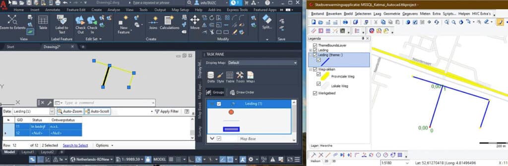
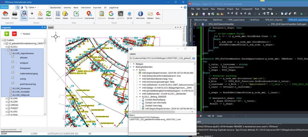
The future is still a bit of a guess, but it is noticeable that GIS as very special in the past, about 20 years ago, has become a main application at many companies and will only become more important in the future," Van Hooren summarizes. "Technological developments, better mathematical algorithms, more extensive functions and the ever-growing speed in processing data means that GIS will continue to grow in the coming decades. SmallToGo provides several products including the STGViewer which can be used to view, query and export many types of data."
Louwers Mediagroep
Schatbeurderlaan 6
6002 ED Weert
 © 1987 - 2025 Louwers Media Group.