Platform on civil engineering, underground infrastructure, energy, construction equipment & construction machinery

CAD Accent | Arkance Systems has released a new version of InfraCAD Map, version 7, offering both new features and enhancements to existing functionality. The main innovations focus on greatly improved methods offered by the Kadaster through its portal 'Publieke Dienstverlening Op de Kaart' (PDOK), such as the BGT and Kadastrale kaart. In addition, InfraCAD Map also supports 4K monitors as of version 7. In this article, we discuss the most important changes.
For some time PDOK's services have been heavily overloaded due to the enormous popularity of the BGT. This results in longer waiting times and recently the downloads appeared increasingly incomplete. The Cadastre has recognized this problem and has been busy setting up a new service. The result is impressive. CAD Accent | Arkance Systems has closely followed the developments and implemented them in the new version of InfraCAD Map.
Requesting BGT and Cadastral map has changed the way it works. Previously, the area was compiled "real-time" during the download. In the new method, an area is requested by the user and already compiled directly on the PDOK servers. After this, this area is made available as a download file and remains available for about one working day. The big advantage is that the user no longer has to wait between the request and processing and can request several areas at once. In InfraCAD Map it has therefore been made possible to request multiple areas in batch and process them at a later time. It is now also possible to save the processed areas. This way they can be shared with colleagues or used in other applications such as InfraWorks.
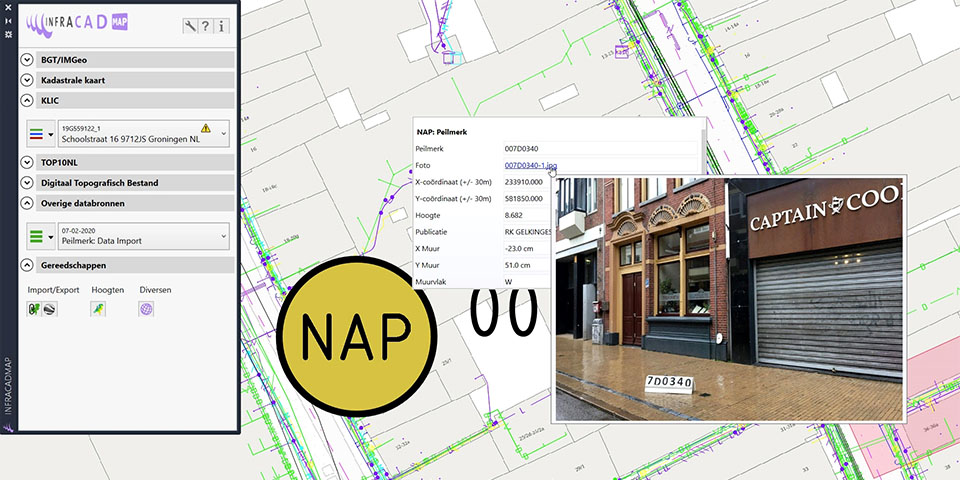
NAP Level mark with photo preview in drawing.
Testing of the new BGT service has shown a huge gain in speed. In the new way of working there are two steps to a drawing. The first step, requesting and downloading the city of Oss (about 15km²), took about a minute and a half. In the second step, the download is processed to a full NLCS drawing in AutoCAD. This took about 3 minutes. With the old method, this took several hours.
For the Cadastral map, the Land Registry continued to support the "old method" until April 1, 2020. As of now, InfraCAD v6 can therefore no longer process a Cadastral map. For BGT, the Land Registry will stop supporting the old method after the summer. So for InfraCAD Map users, it is important to switch to v7 in time.
More and more users are switching to 4K monitors. This requires a complete revamp of the interface (dialog boxes). InfraCAD Map v7 features a completely new look-and-feel; each data source has a clear drop-down and informative tooltips. Wizards have also received a new look-and-feel and are more attuned to the Windows 10 experience.
InfraCAD Map already had the ability to display data from Klic notifications in a pop-up window. In the new version, this functionality has been extended to almost all data sources made available by PDOK and the National Geo Register (NGR). Through this the pop-up can be used to view the linked administrative data and filter on certain properties.
A frequently requested user wish was to be able to export administrative data, for example to a GIS environment. InfraCAD Map v7 can now convert this data to Object Data and to Property Sets, which can be used with AutoCAD Map 3D or Civil 3D. The drawing can then be exported to another file format such as Esri Shape as desired, while retaining the original data.
Even when exporting to KML, the data can now be included so that it is available in Google Earth.
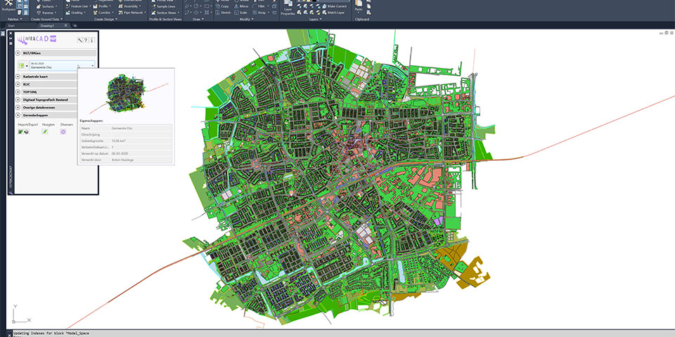
The new layout of InfraCAD Map with area properties.
Some sources at PDOK and NGR are updated with some regularity, others are compiled only once after which a new version is developed. For example, the AHN3 has now become national coverage and the Aerial Photo 2019 has become available since the beginning of this year. These sources themselves are no longer updated because work is now beginning on the acquisition of AHN4 and Aerial Photo 2020.
The data sources in InfraCAD Map have been optimized and provided with administrative data. A nice improvement is that for the NAP Level marks, a picture is now also retrieved, if available. This is shown in the pop-up.
The new version of InfraCAD Map comes at a good time. The new, fast processing of BGT and Cadastral map will be a relief for many users. And it is, of course, fully compliant with the NLCS. The ability to reuse administrative data in other systems is another strong point. Combined with the fresh new layout and support for 4K monitors, CAD Accent | Arkance Systems has released a version that will be welcomed with open arms.