Platform on civil engineering, underground infrastructure, energy, construction equipment & construction machinery
InfraCAD v8.2 and InfraCAD Map v8.2 have been updated
ARKANCE has recently released the latest version of InfraCAD and InfraCAD Map (Desktop). It is recommended to install this new v8.2 version as there are some improvements and new functionality that are worthwhile.
Below is a summary of the major changes.
Autodesk's cloud environment is used by some users to share the NLCS library with colleagues. Sometimes this is also done via OneDrive. These cloud solutions constantly synchronize the files to the local computer, and this does not always seem to work well with InfraCAD. For example, previews are not shown of symbols. There is now a setting in InfraCAD that causes the preview to be processed differently and therefore visible.
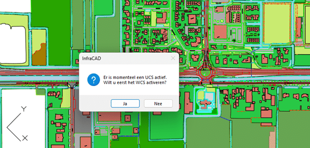
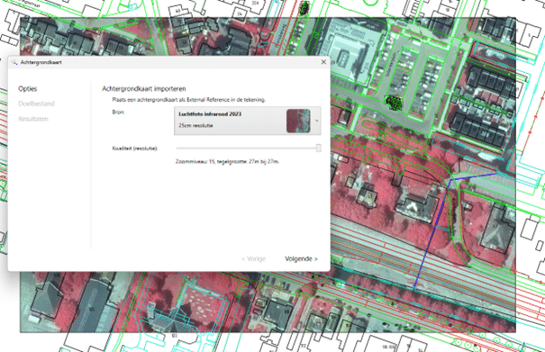
For some projects, a UCS is set up to be easier to work with. But then when an External Reference is read in, it may end up in the wrong location. InfraCAD now notifies if this is the case, and will switch back to the WCS, if desired. Infrared aerial photo
A frequently requested wish, to be able to import the infrared aerial photo in addition to the regular aerial photo. Unfortunately, this is not available in the 7.5cmpp resolution, but 25cm is still perfectly acceptable. With InfraCAD Map, this is easy to import.
The "regular" aerial photo is still available, of course. And in the settings, you can now specify whether the background map should be saved as PNG or JPG.
Unfortunately, two data sources have also been dropped. It concerns the DTB and the NAP level marks. The latter is no longer offered on PDOK by the source owner Rijkswaterstaat. Sometimes it happens that a source holder stops making it accessible on PDOK and then we have to consider whether we can process it in another way or remove the source from the application. The same applies more or less to the DTB. For quite some time now, this source has not been available as 3D data, which was once the very reason for us to add the source to InfraCAD Map. Despite repeated requests, the source owner (in this case also Rijkswaterstaat) refuses to restore the data. The delivery of new data also faltered regularly, which is why we had to decide to no longer make this source accessible via the application.
New Lisp functions are now available that indicate whether the Palette is active, thus keeping a license occupied. Also, the Palette can be closed. A godsend for CAD Managers, to incorporate into the startup script.
The Dutch Country Kit in Civil 3D causes a bug that becomes visible when shading patterns for concrete pavement stone are searched in InfraCAD. InfraCAD has applied a work-around for this by setting the search paths in Civil 3D so that InfraCAD shading patterns are read first and only then those from the Country Kit.
Another great version with many features and improvements. Once again we highly recommend upgrading to the latest version as soon as possible to take advantage of all these changes
Neem dan rechtstreeks contact op met Arkance Systems Netherlands.
We help you make the most of opportunities from digital transformation.
Bekijk Bedrijfsprofiel
