Platform on civil engineering, underground infrastructure, energy, construction equipment & construction machinery
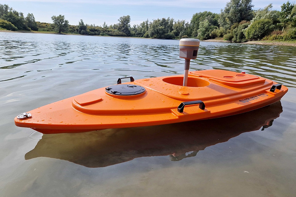
Independent civil engineering and surveying consultancy Infra Plus is grabbing the assignment to map a port in the Netherlands with both hands. They went in search of a remote-controlled survey boat and found it at partner Geometius. Senior surveyor Pieter Blankestijn and surveyor Richard van Loo had the honor of launching the rented survey boat, named Geometius USV.

The assignment concerns a port in the Netherlands that is frequently visited by recreational and tour boats. In order to ensure the safety of the harbor, it is necessary, among other things, to achieve the required navigational depth. Hence the desire of the municipality involved to survey the bottom of the harbor. An assignment that Infra Plus is happy to perform with the deployment of the Geometius USV boat.
Armed with instructions and advice from supplier Geometius, Pieter and Richard let the USV boat loose in the harbor in question early this year to perform depth measurements quickly and easily. This is possible, among other things, because the USV has the single frequency transducer. A sensor that is very suitable for surveys in shallow water. In addition to this technology, Richard praises the simplicity with which the boat is operated and speaks highly of its maneuverability: "We can now easily get between the moored boats in the harbor and do a depth survey there as well." This is possible in part because the boat is only 1.75 meters long and has a light weight of around 25 kilograms.
Of course, motion affects the accuracy of a measurement. Still, according to Pieter, the USV boat can take a beating: "Anything below wind force 4 can be measured well. From there the measurements become sensitive." Richard indicates that the accuracy of the measurements is also ensured by the fact that the boat can record several points per second: "This allows us to give an accurate picture of the underwater situation in the harbor."
The data retrieved consists of depth numbers linked to GPS positions. This data can be processed through a variety of hydrographic software packages. During this project, Hydromagic was chosen. For Infra Plus this was the first time they had worked with this software. According to Pieter a user-friendly process: "Geometius provided an explanation of the software. From this starting point we quickly managed to process the data properly." The result is a visualization of the soil map. When asked if it met expectations, Pieter replied, "Yes, completely. During the fieldwork, we saw real-time data passing by. Based on this, we could tentatively make an assumption regarding the course of the soil. The final data processing confirmed that. So there were no big surprises awaiting us. The result is clear."
The men from Infra Plus look ahead. For example, Pieter sees how the Geometius USV can contribute to carrying out future surveying work more effectively: "As land surveyors, our work focuses mainly on smaller bodies of water, such as watercourses and ponds in residential areas. These are usually no deeper than 1.5 meters. We then enter these on foot with a wading suit or by means of a boat. The USV can simplify this a lot." Richard adds that the deployment of the remote-controlled sounding boat broadens the scope of work: "With this boat, we can easily start recording larger waters. With this, Infra Plus is ready to broaden its services."
When asked if the gentlemen will rent the Geometius USV again, the answer is, "Yes, most definitely! Hopefully we will get to release the boat on the water again soon."

Being able to work anywhere, anytime. Being able to rely on your measuring equipment regardless of the working conditions and always being able to walk in or call if you have a question. This and more you will find with us: We are Geometius. With 30 years of experience in the field we understand you like no other. Geometius provides measurement systems and software for work in the ground, [...]
Bekijk Bedrijfsprofiel