Platform on civil engineering, underground infrastructure, energy, construction equipment & construction machinery

From angle mirror and measuring tapes, to radio positioning and scanners, from post-processing to drones and real-time measuring. The surveying profession has evolved quite a bit in recent decades. Instruments have become smaller, faster and more accurate, and new measuring techniques allow us to take increasingly targeted measurements. Combine high-quality measuring systems with smart software and the right services and a high-quality end product can be realized quickly and easily.
Jasper Schuur of Geometius also agrees. "As a supplier of measuring equipment and systems for positioning (GNSS) and surveying, geographical and hydrographic applications, among other things, with the associated software, Geometius makes surveying as accessible as possible. Surveying 2.0 is the new way of working," according to Schuur. "Software is an essential part of this, because with the right processing software you can make work processes many times more efficient and prevent errors in the field."
Schuur explains: "Because both the measuring instruments and the software are perfectly matched, data is easy to read in and process immediately. This allows the work to be checked in real time and prevents failure costs." Schuur calls this "surely one of the most important and impressive changes in the industry. "Trimble is leading the way in this and we are proud to be their distribution partner for surveying equipment in the Netherlands." However, it's about more than just delivering hardware: "Despite all kinds of new technology, surveying remains human work and the need to check is unchanged. We support our customers in this with telephone support and targeted training."
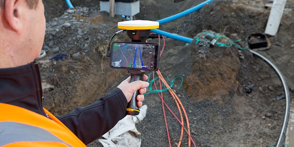
Trimble SiteVision; Augmented reality with RTK accuracy
The lightning-fast developments in software certainly contribute to making surveying more accessible and user-friendly. "Geometius is growing along with this. We believe that the smart combination of software with hardware creates new solutions." In addition to GNSS instruments, Geometius offers a wide range of surveying equipment such as Total Stations, UAVs, 3D scanners and user-friendly processing software that captures and processes images, both on the ground and in the air. In addition, the company provides training and various informative workshops and events to really experience Land Surveying 2.0 for yourself.
Such as the event "The Day of the Point Cloud" organized by Geometius in spring 2019. Collecting, processing and extracting a large amount of information from point clouds is the future within the geo-work field, Schuur believes. During the day, Professor Edward Verbree, associate professor of Geomatics at TU Delft, got the more than 100 attendees thinking with his vision of the point cloud. According to him, much more is possible with the large amount of information in the point cloud: "The added value for interactive and explorative applications is enormous. The question is how to apply this point cloud data more broadly, so that it benefits business processes." A guest speaker from Trimble Geospatial and two users also talked about the scanning tools and the many possibilities offered by a point cloud. "A fascinating conference," says Schuur, "that will undoubtedly be followed up."
It is clear: the almost limitless possibilities of Land Surveying 2.0 are revolutionizing the infrastructure sector. "BIM will increasingly find its way into the GWW. Thanks to cloud solutions, data can be sent very quickly from the field to the office and vice versa." He cites an example where, in combination with Trimble SiteVision, a future structure or junction can be visualized in the field with augmented reality. "A pilot is now underway with a customer where we are visualizing a bicycle bridge in this way. Any 'clashes' become immediately visible. But also less visible issues, such as underground infrastructure, can be visualized with augmented reality. A great development with unprecedented possibilities," concludes Schuur.

Being able to work anywhere, anytime. Being able to rely on your measuring equipment regardless of the working conditions and always being able to walk in or call if you have a question. This and more you will find with us: We are Geometius. With 30 years of experience in the field we understand you like no other. Geometius provides measurement systems and software for work in the ground, [...]
Bekijk Bedrijfsprofiel